26 November 2020, NIICE Commentary 6500
Shreya Shaw
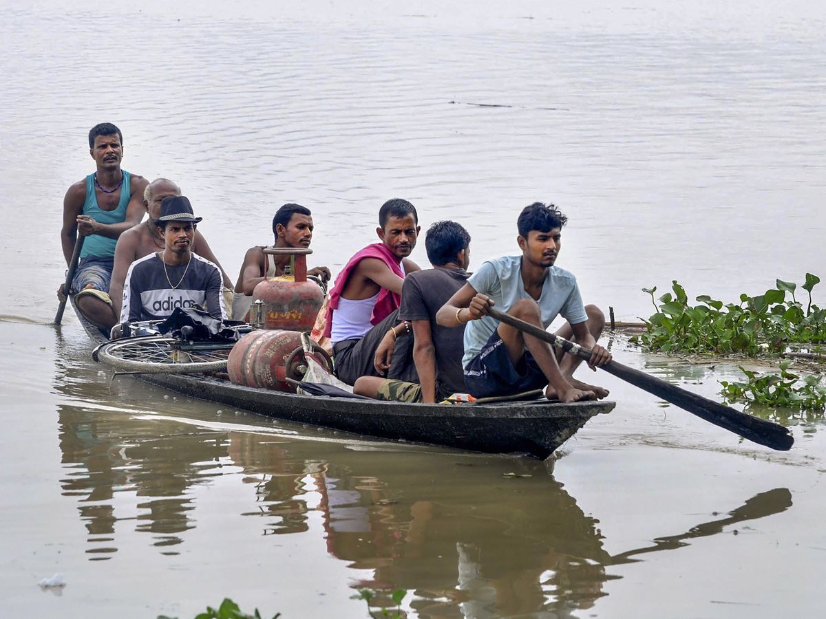
The river Brahmaputra cuts northeast India’s biggest state, Assam, into two halves – the North and the south banks. Every year Assam faces devastating floods. During the post-independence period, Assam faced major floods in 1954, 1962, 1972, 1977, 1984, 1988, 1998, 2002, 2004, 2012, 2014 and 2020. Almost every year, three to four waves of flood ravage the flood-prone areas of Assam. Average annual loss due to surge in Assam is to the tune of Rs. 2 billion and particularly in 1998, the loss suffered was about Rs. 5 billion and during the year 2004 it was about Rs. 7.71 billion. This becomes the natural phenomenon for this region.
The Brahmaputra
The largest river of India’s Northeast, Brahmaputra, is both lifeline and menace to Assam. It has a large river system, of multiple channels and water bodies, crisscrossing large parts of Assam. The Brahmaputra originates from the Angsi glacier located in the northern part of the Tibetan plateau, Himalayan. In Tibet, the name of the Brahmaputra is the Yarlung Tsangpo. After that, the Brahmaputra streams eastwards parallel to the Himalayan, at the Namcha Barwa, which is the mountain in the Tibetan Himalayan. Then it enters Arunachal Pradesh in India.
The Tibetan plateau is the highest and most abundant in the world. When the Brahmaputra river flows from the top to the plain land in Assam, it brings large amount of fertile soils. Several river streams joins the Brahmaputra, namely Subansiri, Ronganadi, Dikrong, Buroi, Borgong, Jiabharali, Dhansiri (North) Puthimari, Manas, Beki, Aie, Sonkosh, Noadehing, Buridehing, Desang, Dikhow, Bhogdoi, Dhansiri (South), Kopilli, Kulsi, Krishnai, Dhdhnoi and Jinjiran.
The Brahmaputra’s sub-basin extends over an area of 580,000 square kilometre lying in Tibet (China), Bhutan, India and Bangladesh. Due to climate change and rise in global temperature, the Himalayan glacier mountains are melting rapidly. As a result, all these rivers and tributaries of the Brahmaputra are overflowing way above their dangerous level. The neighbouring plain and low areas of the region are severely affected by sessional devastating monsoon flood that affects the livelihood of Assam.
The Assam-Tibet earthquake in 1950 impacted the Brahmaputra river basin. The evolution of geomorphic changes in the river basin also effected and changed the fluvial pattern of the river. The visible impact of climate change, on the River basin, for instance, the Majuli River Island (the Ganga–Brahmaputra–Meghna river basin) and the glacial ice melt from the Himalayas and Tibet that triggers floods and bank erosion induced displacement of people.
Embankments
Embankments are the temporary flood measures; Assam governments have spent millions every year. Flood control in Assam lacks a comprehensive vision and long-term planning. For instance, the largest river island of Majuli on the Brahmaputra has now reduced to 50 percent of its size. Erosion is reducing the land size every year. North Lakhimpur, one of the most affected areas of 2008, had reported that earth embankments were the best flood management measures. Till date, over 4,000 km of earth embankments have been constructed. However, when the Brahmaputra breaks those embankments, it causes massive destruction.
Out of a total land area of 7.8 million hectares in Assam, more than 2.8 million hectares or 36 percent of the total area is affected by floods from time to time. These temporary measures like embankments trooped due to lack of planning of Assam government and at the same time people inhabited in those areas are also not aware of its consequences. The Brahmaputra River is becoming more devastating day by day due to the increase in the rate of melting of glaciers in Himalayas.
Dehing and Patkai
The rich biodiversity of Northeast India is a matter of concern. Dehing and Patkai wildlife sanctuary called “Amazon of the East, Rain Forest, Elephant Reserves” for the rich diversity of the land. Dehing-Patkai landscape comes under Indo-Burma biodiversity hotspot for its rich flora and fauna diversity. This landscape is home to various IUCN listed species like- Asian Elephant, Royal Bengal Tigers, Indian Leopard, Clouded Leopard, Himalayan Beer, Pangolin, Wild Cat, Barking Deer, Hoolock Gibbon, Slow Loris, Pig-Tailed Macaque, Stump-Tailed Macaque and Capped Langur. Apart from these, there are 293 species of bird, 30 species of butterflies, 47 species of reptiles, 24 species of amphibians including 100 species of orchids.
Coal mining in Dehing and Patkai is now a matter of violation of the Forest (Conservation) Act 1980 and Coal Mines Act (Special Provisions) 2015. The Union Ministry of Environment, Forest and Climate Change (MoEFCC) determined industrial and infrastructure projects within the wildlife sanctuary. The ministry has proposed a new set of rules, i.e. the draft Environment Impact Assessment (EIA). The National Board of Wildlife (NBWL) passed the recommendation of coal mining in January 2020, which is the threat of biological diversity upon the region. Environmentalist, climatologist, ecologist, conservationists, naturalists and many scientists work for the environment and pollution-free forest but the coal mining causes the biggest threat.
The National Board for Wildlife (NBWL) has given permission to the Coal India Limited for extraction of 98.59 hectares land of Saleki which belongs to the Dehing Patkai Wildlife Reserve. The area is already threatened by pollution due to industries and refineries nearby. Dehing and Patkai are located in the Dibrugarh, Tinsukia and Sivasagar districts of Assam, and it covers a total area of 111.19 square kilometre. Dehing is the river that flows through the forest which is the habitation for a dozen different ethnic groups such as Tai Phake, Khamyang, Khamti, Moran, Ahom, Muttack, Nepali people and Tea-tribes. The central government is trying to harm the environment of Dhing Patkai, Assam. Recently the massive tree cutting for coal mining brought countless threat to the Himalayan belt region of Assam causing devastating floods. The coal mining, rampant deforestation, destroying the natural diversity and animals has imbalanced the enviroment.
Kaziranga National Park and Tiger Reserve (KNPTR)
Every year deluge is essential for the UNESCO World Heritage Site recognized - Kaziranga National Park and Tiger Reserve (KNPTR). The annual flood is good for its wildlife sanctuary. It helps replenish Kaziranga’s water bodies and maintain its landscape, a mix of wetlands, grasslands and semi-evergreen deciduous forests. The waters also help get rid of unwanted plants such as water hyacinth which collect in huge masses in the landscape. If it were not for the annual floods, the area would become a woodland. Initially big floods used to come after ten years; currently, it comes every year. It happened due to clime change. In 2016 to 2020, Kaziranga faced high floods; as a result, more than 60 percent of the park was underwater and hundreds of animals were killed and injured. The state government of Assam should take proper measures for the conservation of World Heritage and sanctuary like Dehing, Patkai and Kaziranga Park.